What are we up to?
|
|
|
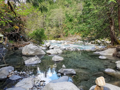
In partnership with Xa'xtsa First Nation, TTQ Economic Development Corporation, and Trails and Recreation Sites of British Columbia, the University of Victoria is pursuing an investigation that explores local and regional hydrogeology of the Sloquet spring system to understand geothermal resources that exist.
Researchers are interested in answering various scientific questions including, but not limited to:
Researchers are interested in answering various scientific questions including, but not limited to:
- What depth does thermal water originate from?
- What is the temperature of water at depth?
- What geologic structures are present that allow thermal water to discharge at land surface?
- What other seepage sites exist?
- What does water geochemistry tell us about the system at depth?
- What does the groundwater flow regime look like locally, and regionally?
How are we going to answer scientific questions?
To answer research questions, our team must be focused on conducting thorough investigations of local systems to capture the relationship between the geologic setting, fluid flow and temperature gradients. Collectively, we will evaluate geothermal resources at Sloquet thermal springs through various methodologies, including:
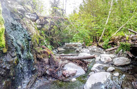
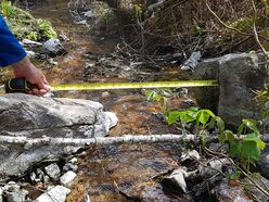
- Field reconnaissance at a nested scale (hundreds of meters) to collect data on Sloquet thermal springs. Field work will evaluate the local geology such as bedrock, structures, distribution of thermal seepage sites, water temperature, and surficial deposits.
- Drill 1-2 wells to evaluate the local lithology and hydraulic properties of the subsurface while also monitoring groundwater levels at depth and the potential geothermal gradient of the subsurface.
- Water sampling at various locations including within the wells, the main spring discharge site, thermal pools, river and other identified seepage sites. The purpose of collecting water samples is to evaluate the geochemistry to better understand temperature at depth, fluid-rock interactions, recharge sources, residence times and reservoir location.
- Passive remote sensing using thermal infrared imaging to capture heat distribution across the land surface.
- Develop two hydro-geothermal conceptual models that integrate hydrogeology, temperature gradients and system behavior. Two scales will be offered from conceptual models including local (hundreds of meters) and regional (km’s).
Project Partners
|

|

|
